
Srinagar: In a landmark shift with direct implications for Jammu & Kashmir, the Union Territory has been placed in India’s newly created highest-risk seismic Zone VI, according to a radical overhaul of the country’s earthquake hazard map released by the Bureau of Indian Standards (BIS).
The reclassification, issued under the revised Earthquake Design Code, marks the strongest official acknowledgement yet of the extreme tectonic stresses underlying the Himalayan region.
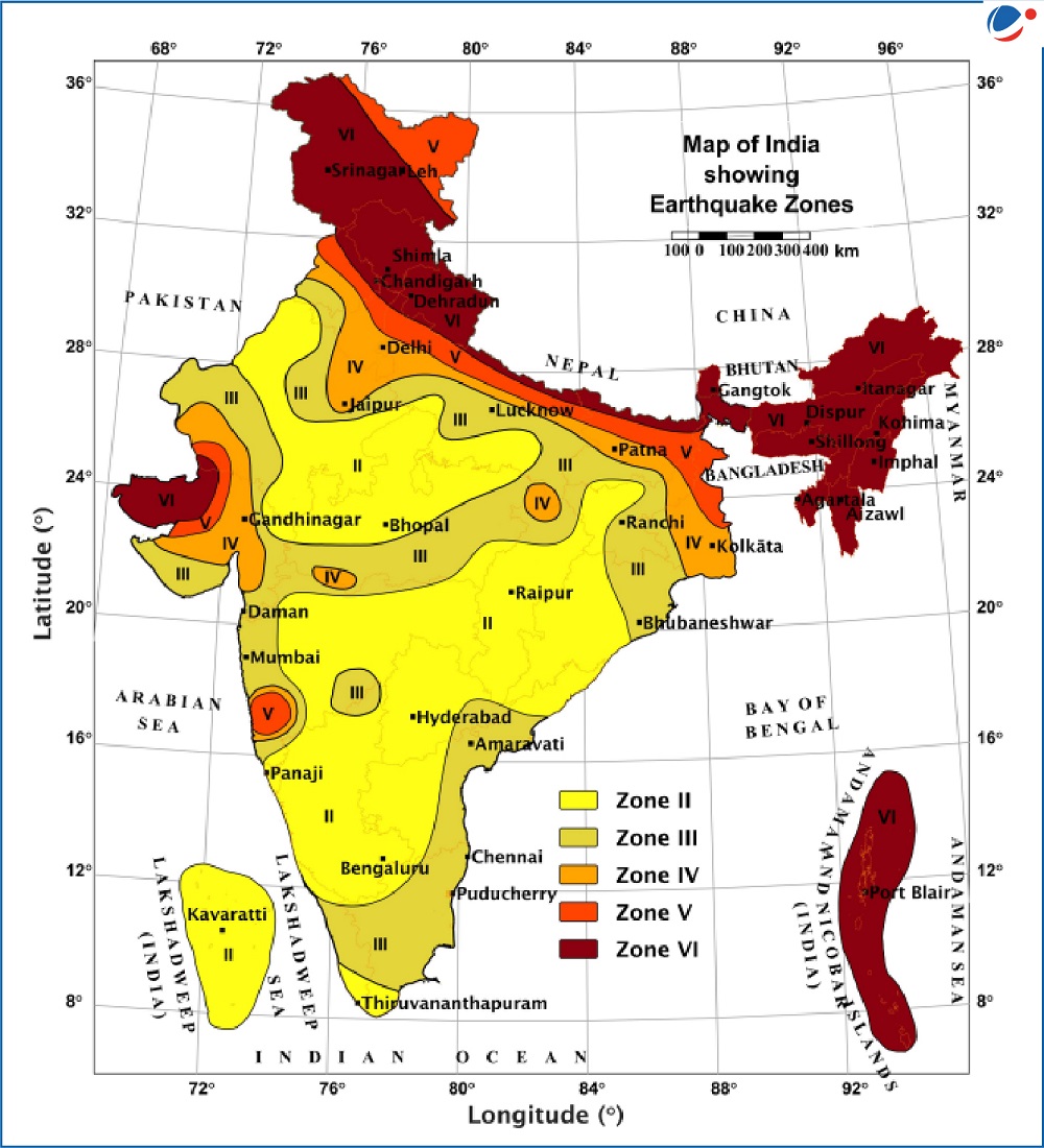
With the updated map, the entire Himalayan stretch from J&K to Arunachal Pradesh has now been grouped under Zone VI—an unprecedented move that unifies the mountain arc under a single, severe-risk category. Scientists say the change corrects earlier inconsistencies that split the Himalayas across Zones IV and V despite all segments being threaded by the same active megathrust fault.
The new hazard zonation also reveals that 61% of India’s landmass falls under moderate to high seismic zones, with nearly 75% of the population living in areas vulnerable to strong ground shaking. For J&K—situated atop one of the most geologically active sections of the Himalayan collision zone—the upgrade signifies heightened urgency for seismic-resilient construction, retrofitting of critical facilities and stricter enforcement of building norms.
Experts say the revised map moves India decisively toward probabilistic seismic hazard assessment (PSHA), a global standard that uses fault-specific data, maximum expected magnitudes, soil response, and ground-motion modelling.
“The updated map finally brings uniformity to the Himalayan belt,” said Vineet Gahalaut, director of the Wadia Institute of Himalayan Geology. “Earlier zonation underestimated the hazard posed by long-locked fault sections that have accumulated strain for nearly two centuries.”
Environmental and seismic-risk analyst Rajesh Solomon Paul called the reclassification a “historic shift”. In an interview with television channel ETV Bharat, Paul noted that the new Zone VI tag for J&K and other Himalayan states reflects the very high likelihood of major earthquakes capable of producing severe ground motion. He emphasised that foothill towns and urban clusters must now treat seismic preparedness as non-negotiable.
The revised Earthquake Design Code introduces sweeping mandates:
• Critical infrastructure in J&K—hospitals, schools, bridges, emergency centres—must remain functional even after strong quakes.
• Heavy non-structural elements, such as water tanks, parapets and façade panels, must be anchored to prevent internal collapse.
• Site-specific spectra, local soil effects, liquefaction potential and near-fault ground-motion pulses must be incorporated into all engineering designs.
For the first time, BIS has also introduced an exposure layer that blends hazard with population density, construction concentration and economic vulnerability. This places added pressure on rapidly expanding urban pockets of J&K—including Srinagar and towns along the Jhelum basin—where unregulated construction increases potential losses.
While southern India saw minor updates due to stable tectonics, the Himalayan states—including J&K—face a complete reorientation of building bylaws, mandatory seismic audits, retrofitting drives and stricter geotechnical scrutiny for new projects.
With scientists warning that parts of the central Himalaya are overdue for a large rupture, the new map stands as a stark reminder: for J&K, preparedness is no longer optional but urgent.